Socorro: what to see and where to eat

Everything below comes from open data and each row says where it came from. We have not been to any of these places and we do not rank them.

31,115 people live here

Distances are straight-line and the walking time is an estimate, not a route.

Filters

Things to see

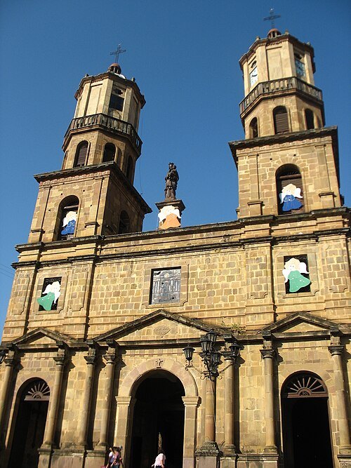
  • Cathedral of the Holy Cross

    Tecsie (Augusto Sisa) / CC BY-SA 3.0

    catholic cathedral

    Cathedral of the Holy Cross

    Opening hours Not checked

    Admission Not checked

    Getting there Nearest stop or station San Gil Terminalito - Local Bus Station, about 6 min on foot OpenStreetMap

    About 17 km from the city centre

    Map

  • mountain

    Alto Las Niguas

    mountain in Colombia

    Opening hours Not checked

    Admission Not checked

    About 12 km from the city centre

    Map

  • park

    Parque Galineral

    park in Colombia

    Opening hours Not checked

    Admission Not checked

    Getting there Nearest stop or station San Gil Terminalito - Local Bus Station, about 16 min on foot OpenStreetMap

    About 17 km from the city centre

    Map

  • park

    Parque Principal

    park in Colombia

    Opening hours Not checked

    Admission Not checked

    Getting there Nearest stop or station San Gil Terminalito - Local Bus Station, about 6 min on foot OpenStreetMap

    About 17 km from the city centre

    Map

  • mountain

    Cerro Sibalbín

    mountain in Colombia

    Opening hours Not checked

    Admission Not checked

    About 12 km from the city centre

    Map

  • mountain

    Cerro Alta Cruz

    mountain in Colombia

    Opening hours Not checked

    Admission Not checked

    About 11 km from the city centre

    Map

  • mountain

    Cerro Páramo

    mountain in Colombia

    Opening hours Not checked

    Admission Not checked

    About 13 km from the city centre

    Map

  • hill

    Cuchilla Carbonera

    hill in Colombia

    Opening hours Not checked

    Admission Not checked

    About 13 km from the city centre

    Map

  • hill

    Alto Arenas Blancas

    hill in Colombia

    Opening hours Not checked

    Admission Not checked

    About 17 km from the city centre

    Map

  • mountain

    Alto Pan de Azúcar

    mountain in Colombia

    Opening hours Not checked

    Admission Not checked

    About 17 km from the city centre

    Map

  • hill

    Loma Medio Mundo

    hill in Colombia

    Opening hours Not checked

    Admission Not checked

    About 12 km from the city centre

    Map

  • hill

    Loma La Cuchilla

    hill in Colombia

    Opening hours Not checked

    Admission Not checked

    About 9 km from the city centre

    Map

  • hill

    Alto Las Pavas

    hill in Colombia

    Opening hours Not checked

    Admission Not checked

    About 11 km from the city centre

    Map

  • hill

    Loma La Falda

    hill in Colombia

    Opening hours Not checked

    Admission Not checked

    About 16 km from the city centre

    Map

  • mountain

    Alto Cara de Perro

    mountain in Colombia

    Opening hours Not checked

    Admission Not checked

    About 18 km from the city centre

    Map

  • mountain

    Alto Las Cruces

    mountain in Colombia

    Opening hours Not checked

    Admission Not checked

    About 19 km from the city centre

    Map

  • hill

    Loma del Río

    hill in Colombia

    Opening hours Not checked

    Admission Not checked

    About 12 km from the city centre

    Map

  • hill

    Loma Montecristo

    hill in Colombia

    Opening hours Not checked

    Admission Not checked

    Map

  • mountain

    Alto Las Escaleras

    mountain in Colombia

    Opening hours Not checked

    Admission Not checked

    About 19 km from the city centre

    Map

  • mountain

    Alto Caracuchal

    mountain in Colombia

    Opening hours Not checked

    Admission Not checked

    About 18 km from the city centre

    Map

  • mountain

    Alto El Cajón

    mountain in Colombia

    Opening hours Not checked

    Admission Not checked

    About 20 km from the city centre

    Map

  • mountain

    Alto El Cajón

    mountain in Santander Department, Colombia

    Opening hours Not checked

    Admission Not checked

    About 20 km from the city centre

    Map

  • hill

    Filo del Hambre

    hill in Colombia

    Opening hours Not checked

    Admission Not checked

    About 17 km from the city centre

    Map

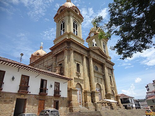
  • Co-Cathedral Basilica of Our Lady of Help, Socorro

    Kaluaran / CC BY-SA 3.0

    catholic cathedral

    Co-Cathedral Basilica of Our Lady of Help, Socorro

    Opening hours Not checked

    Admission Not checked

    Getting there Nearest stop or station Terminal de Transportes, about 5 min on foot OpenStreetMap

    Map

Places to eat

No eating place in this city lists its cuisine and opening hours yet.

Opening hours and tickets: OpenStreetMap contributors. Each one shows the day a volunteer last wrote it down, so check the official site before you set out.

Nothing picked yet
    Add a place that is not listed here

    One per line. Pasting a list works too.

    Colombia