Sincelejo: what to see and where to eat

Everything below comes from open data and each row says where it came from. We have not been to any of these places and we do not rank them.

286,716 people live here

Nearest airport: Las Brujas Airport (CZU), about 12.72 km from the centre

Distances are straight-line and the walking time is an estimate, not a route.

Filters

Things to see

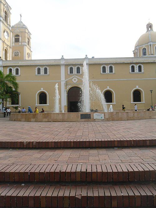
  • St. Francis of Assisi Cathedral, Sincelejo

    DanielaHernández18 / CC BY-SA 4.0

    catholic cathedral

    St. Francis of Assisi Cathedral, Sincelejo

    church in Sincelejo, Colombia

    Opening hours Not checked

    Admission Not checked

    Getting there Nearest stop or station Transporte Chinú, about 15 min on foot OpenStreetMap

    Map

  • lake

    Ciénaga de Trementino

    lake in Colombia

    Opening hours Not checked

    Admission Not checked

    About 38 km from the city centre

    Map

  • association football venue

    Estadio Armando Tuirán Paternina

    football stadium

    Opening hours Not checked

    Admission Not checked

    About 38 km from the city centre

    Map

  • hill

    Cuchilla de Providencia

    hill in Colombia

    Opening hours Not checked

    Admission Not checked

    About 34 km from the city centre

    Map

  • hill

    Cuchilla Mancamo

    hill in Colombia

    Opening hours Not checked

    Admission Not checked

    About 33 km from the city centre

    Map

  • lagoon

    Ciénaga de Leche

    lagoon in Colombia

    Opening hours Not checked

    Admission Not checked

    About 33 km from the city centre

    Map

  • mountain

    Loma Grande

    mountain in Colombia

    Opening hours Not checked

    Admission Not checked

    About 30 km from the city centre

    Map

  • hill

    Loma El Púlpito

    hill in Colombia

    Opening hours Not checked

    Admission Not checked

    About 19 km from the city centre

    Map

  • hill

    Serrania de Coraza

    hill in Colombia

    Opening hours Not checked

    Admission Not checked

    About 21 km from the city centre

    Map

  • hill

    Cuchilla la Campana

    hill in Colombia

    Opening hours Not checked

    Admission Not checked

    About 26 km from the city centre

    Map

  • baseball venue

    Estadio 20 de Enero

    Opening hours Not checked

    Admission Not checked

    Map

  • hill

    Colina Tofeme

    hill in Colombia

    Opening hours Not checked

    Admission Not checked

    About 32 km from the city centre

    Map

  • hill

    Cerro Sierra Chiquita

    hill in Colombia

    Opening hours Not checked

    Admission Not checked

    About 29 km from the city centre

    Map

  • hill

    Loma del Silencio

    hill in Colombia

    Opening hours Not checked

    Admission Not checked

    About 31 km from the city centre

    Map

  • hill

    Loma Santa Elena

    hill in Colombia

    Opening hours Not checked

    Admission Not checked

    Map

  • hill

    Serrania San Jeronimo

    hill in Colombia

    Opening hours Not checked

    Admission Not checked

    About 18 km from the city centre

    Map

  • hill

    Serrania de San Jeronimo

    hill in Colombia

    Opening hours Not checked

    Admission Not checked

    Map

  • peninsula

    Punta San José

    peninsula in Sucre Department, Colombia

    Opening hours Not checked

    Admission Not checked

    About 35 km from the city centre

    Map

  • hill

    Colina Popó

    hill in Colombia

    Opening hours Not checked

    Admission Not checked

    About 24 km from the city centre

    Map

  • lake

    Charco Rabon

    lake in Colombia

    Opening hours Not checked

    Admission Not checked

    About 32 km from the city centre

    Map

  • hill

    Alto Petaca

    hill in Colombia

    Opening hours Not checked

    Admission Not checked

    About 12 km from the city centre

    Map

  • peninsula

    Punta Piedra

    peninsula in Sucre Department, Colombia

    Opening hours Not checked

    Admission Not checked

    About 31 km from the city centre

    Map

  • peninsula

    Punta Palancal

    peninsula in Córdoba Department, Colombia

    Opening hours Not checked

    Admission Not checked

    About 39 km from the city centre

    Map

  • lagoon

    Playon de Momil

    lagoon in Colombia

    Opening hours Not checked

    Admission Not checked

    About 31 km from the city centre

    Map

  • peninsula

    Punta Madre de Dios

    peninsula in Sucre Department, Colombia

    Opening hours Not checked

    Admission Not checked

    About 34 km from the city centre

    Map

  • lagoon

    Ciénaga Hoyo León

    lagoon in Colombia

    Opening hours Not checked

    Admission Not checked

    About 39 km from the city centre

    Map

  • lagoon

    Ciénaga los Charcos

    lagoon in Colombia

    Opening hours Not checked

    Admission Not checked

    About 32 km from the city centre

    Map

  • hill

    Loma Carediablo

    hill in Colombia

    Opening hours Not checked

    Admission Not checked

    About 37 km from the city centre

    Map

  • peninsula

    Punta Bolívar

    peninsula in Córdoba Department, Colombia

    Opening hours Not checked

    Admission Not checked

    About 39 km from the city centre

    Map

  • hill

    Colinas de Bomba

    hill in Colombia

    Opening hours Not checked

    Admission Not checked

    About 14 km from the city centre

    Map

Places to eat

No eating place in this city lists its cuisine and opening hours yet.

Opening hours and tickets: OpenStreetMap contributors. Each one shows the day a volunteer last wrote it down, so check the official site before you set out.

Nothing picked yet
    Add a place that is not listed here

    One per line. Pasting a list works too.

    Colombia