Tacloban: what to see and where to eat

Everything below comes from open data and each row says where it came from. We have not been to any of these places and we do not rank them.

259,353 people live here

Nearest airport: Daniel Z. Romualdez Airport (TAC), about 3.1 km from the centre

Distances are straight-line and the walking time is an estimate, not a route.

Filters

Things to see

  • national park

    MacArthur Landing Memorial National Park

    national park in the Philippines

    Opening hours Not checked

    Admission Not checked

    About 8 km from the city centre

    Map

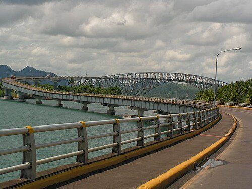
  • San Juanico Bridge

    byron alcantara from Fredon, United States / Public domain

    truss bridge

    San Juanico Bridge

    long truss bridge in the Philippines

    Opening hours Not checked

    Admission Not checked

    Map

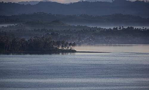
  • San Pedro Bay

    Staff Sgt. Jeffrey Anderson / Public domain

    bay

    San Pedro Bay

    bay at the northwest end of the Leyte Gulf, Philippines

    Opening hours Not checked

    Admission Not checked

    About 12 km from the city centre

    Map

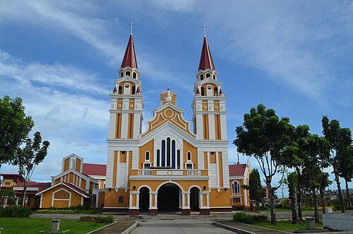
  • Palo Cathedral

    Jojit Ballesteros / CC BY 4.0

    catholic cathedral

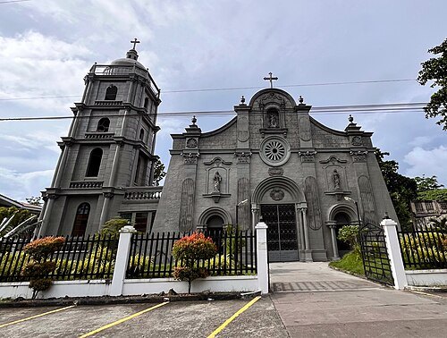
    Palo Cathedral

    Roman Catholic cathedral in Palo, Leyte, Philippines

    Opening hours Not checked

    Admission Not checked

    About 10 km from the city centre

    Map

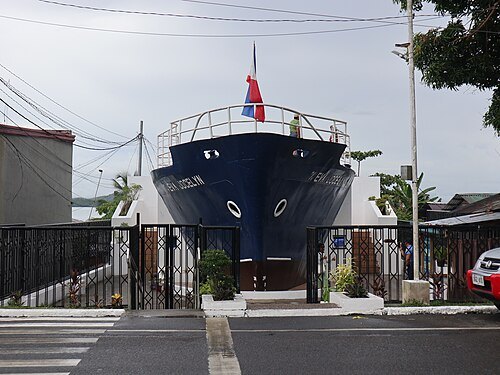
  • Yolanda Shipwreck Memorial Park

    Patrickroque01 / CC BY-SA 4.0

    monument

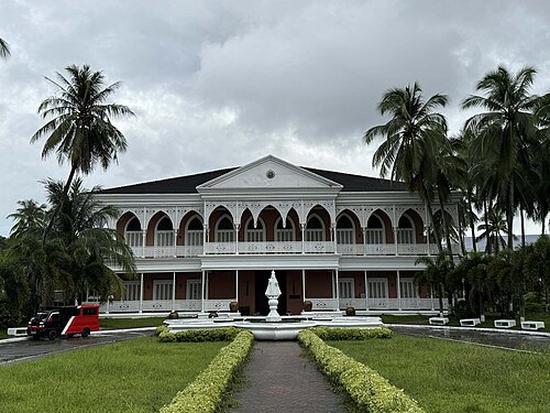
    Yolanda Shipwreck Memorial Park

    memorial park and monument in Philippines

    Opening hours Not checked

    Admission Not checked

    Getting there Nearest stop or station Port of Tacloban City, about 14 min on foot OpenStreetMap
    Map

  • hill

    Mount Danglay

    hill in the Philippines

    Opening hours Not checked

    Admission Not checked

    Map

  • Tanauan Church

    Lightningscale / CC0

    catholic parish church

    Tanauan Church

    Roman Catholic parish church in Tanauan, Leyte, Philippines

    Opening hours Not checked

    Admission Not checked

    About 15 km from the city centre

    Map

  • Santo Niño Shrine and Heritage Museum

    Bap Flores / CC0

    museum

    Santo Niño Shrine and Heritage Museum

    Museum in Tacloban, Philippines

    Opening hours Not checked

    Admission Not checked

    Getting there Nearest stop or station Duptours, about 9 min on foot OpenStreetMap
    Map

  • Basey Church

    Iloilo Wanderer / CC BY-SA 4.0

    catholic parish church

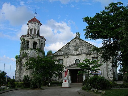
    Basey Church

    church in Basey, Samar

    Opening hours Not checked

    Admission Not checked

    Getting there Nearest stop or station Basey Terminal, about 7 min on foot OpenStreetMap

    About 8 km from the city centre

    Map

  • island

    Bacol Island

    island in the Philippines

    Opening hours Not checked

    Admission Not checked

    About 18 km from the city centre

    Map

  • mountain

    Bagahupi Peak

    mountain in Philippines

    Opening hours Not checked

    Admission Not checked

    About 15 km from the city centre

    Map

  • island

    Bagalibas Island

    island in the Philippines

    Opening hours Not checked

    Admission Not checked

    About 16 km from the city centre

    Map

  • island group

    Camoropudan Islets

    Opening hours Not checked

    Admission Not checked

    About 19 km from the city centre

    Map

  • island

    Cangom Island

    island in the Philippines

    Opening hours Not checked

    Admission Not checked

    About 9 km from the city centre

    Map

  • island

    Capunluran Island

    island in the Philippines

    Opening hours Not checked

    Admission Not checked

    About 10 km from the city centre

    Map

  • island

    Dampigan Island

    island in the Philippines

    Opening hours Not checked

    Admission Not checked

    About 11 km from the city centre

    Map

  • island group

    Uson Islands

    Opening hours Not checked

    Admission Not checked

    About 14 km from the city centre

    Map

  • island

    Enoruan Island

    island in the Philippines

    Opening hours Not checked

    Admission Not checked

    Map

  • island group

    Guintiguian Islands

    Opening hours Not checked

    Admission Not checked

    About 17 km from the city centre

    Map

  • island

    Jinamoc Island

    island in the Philippines

    Opening hours Not checked

    Admission Not checked

    About 8 km from the city centre

    Map

  • island

    Kansitong Island

    island in the Philippines

    Opening hours Not checked

    Admission Not checked

    About 13 km from the city centre

    Map

  • island

    Karapakan Island

    island in the Philippines

    Opening hours Not checked

    Admission Not checked

    About 14 km from the city centre

    Map

  • island

    Magsumbul Daco Island

    island in the Philippines

    Opening hours Not checked

    Admission Not checked

    About 11 km from the city centre

    Map

  • island

    Magsumbul Diutay Island

    island in the Philippines

    Opening hours Not checked

    Admission Not checked

    About 11 km from the city centre

    Map

  • island

    Nababuy Island

    island in the Philippines

    Opening hours Not checked

    Admission Not checked

    About 20 km from the city centre

    Map

  • island

    Pangabaton Island

    island in the Philippines

    Opening hours Not checked

    Admission Not checked

    About 16 km from the city centre

    Map

  • island

    Punubulu Island

    island in the Philippines

    Opening hours Not checked

    Admission Not checked

    About 13 km from the city centre

    Map

  • island

    Sagasumbut Island

    island in the Philippines

    Opening hours Not checked

    Admission Not checked

    About 11 km from the city centre

    Map

  • island

    Torre Island

    island in the Philippines

    Opening hours Not checked

    Admission Not checked

    About 19 km from the city centre

    Map

  • river

    Apolagon River

    river in the Philippines

    Opening hours Not checked

    Admission Not checked

    About 17 km from the city centre

    Map

  • river

    Baghupi River

    river in the Philippines

    Opening hours Not checked

    Admission Not checked

    About 13 km from the city centre

    Map

  • river

    Balang River

    river in the Philippines

    Opening hours Not checked

    Admission Not checked

    About 14 km from the city centre

    Map

  • river

    Barugwan River

    river in the Philippines

    Opening hours Not checked

    Admission Not checked

    About 9 km from the city centre

    Map

  • river

    Basey River

    river in the Philippines

    Opening hours Not checked

    Admission Not checked

    About 11 km from the city centre

    Map

  • river

    Busay River

    river in Leyte, Philippines

    Opening hours Not checked

    Admission Not checked

    About 18 km from the city centre

    Map

  • river

    Cabiyongan River

    river in the Philippines

    Opening hours Not checked

    Admission Not checked

    About 19 km from the city centre

    Map

  • river

    Cawayan River

    river in Samar, Philippines

    Opening hours Not checked

    Admission Not checked

    About 11 km from the city centre

    Map

  • river

    Dampigan River

    river in the Philippines

    Opening hours Not checked

    Admission Not checked

    About 10 km from the city centre

    Map

  • river

    Talucdangan River

    river in the Philippines
    Opening hours Not checked

    Admission Not checked

    About 19 km from the city centre

    Map

  • Saint Michael the Archangel Parish Church

    LMP 2001 / CC BY-SA 4.0

    catholic parish church

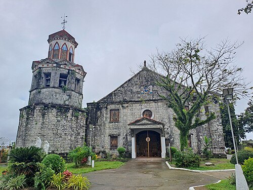
    Saint Michael the Archangel Parish Church

    Roman Catholic church in Basey, Samar, Philippines

    Opening hours Not checked

    Admission Not checked

    Getting there Nearest stop or station Basey Terminal, about 7 min on foot OpenStreetMap

    About 8 km from the city centre

    Map

  • reef

    Palo Reef

    reef in the Philippines

    Opening hours Not checked

    Admission Not checked

    About 9 km from the city centre

    Map

  • island

    Bacalan Island

    Opening hours Not checked

    Admission Not checked

    Map

  • island

    Bagacay Island

    island in the Philippines

    Opening hours Not checked

    Admission Not checked

    Map

  • mountain

    Mount Naganaga

    mountain in the Philippines

    Opening hours Not checked

    Admission Not checked

    Map

  • mountain

    Mount Guinhandang

    mountain in the Philippines

    Opening hours Not checked

    Admission Not checked

    About 9 km from the city centre

    Map

  • mountain

    Mount Guinhandang

    mountain in Philippines

    Opening hours Not checked

    Admission Not checked

    About 9 km from the city centre

    Map

  • island

    Bucay Island

    island in the Philippines

    Opening hours Not checked

    Admission Not checked

    Getting there Nearest stop or station Borongan Transport Terminal, about 20 min on foot OpenStreetMap

    Map

  • peninsula

    Tacloban Peninsula

    peninsula in Leyte, Eastern Visayas

    Opening hours Not checked

    Admission Not checked

    Getting there Nearest stop or station Provincial Bus, about 12 min on foot OpenStreetMap

    Map

  • island

    Dio Islet

    island in the Philippines

    Opening hours Not checked

    Admission Not checked

    Map

  • island

    Lazaretto Island

    island in the Philippines

    Opening hours Not checked

    Admission Not checked

    Map

  • island

    Redondo Island

    island in the Philippines

    Opening hours Not checked

    Admission Not checked

    Map

  • river

    Barayan River

    river in the Philippines

    Opening hours Not checked

    Admission Not checked

    Map

  • river

    Binahaan River

    river in Leyte, Philippines

    Opening hours Not checked

    Admission Not checked

    About 15 km from the city centre

    Map

  • river

    Cambatista River

    river in the Philippines

    Opening hours Not checked

    Admission Not checked

    About 16 km from the city centre

    Map

  • river

    Diit River

    river in the Philippines

    Opening hours Not checked

    Admission Not checked

    Map

  • river

    Tanauan River

    river in the Philippines

    Opening hours Not checked

    Admission Not checked

    About 15 km from the city centre

    Map

Places to eat

  • restaurant

    Cafe Esquinita

    Food: filipino, asian, coffee shop, bubble tea, frappe

    Mo-Sa 09:00-20:00

    Tacloban

    Map

  • restaurant

    Royal Kitchen

    Food: chinese food

    Mo-Fr 08:00-21:00

    Tacloban

    Map

  • restaurant

    JO's Milagrina Tacloban

    Food: chicken

    11:00-21:00

    Tacloban

    Map

Opening hours and tickets: OpenStreetMap contributors. Each one shows the day a volunteer last wrote it down, so check the official site before you set out.

Nothing picked yet
    Add a place that is not listed here

    One per line. Pasting a list works too.

    Philippines