Gracias: what to see and where to eat

Everything below comes from open data and each row says where it came from. We have not been to any of these places and we do not rank them.

47,622 people live here

Nearest airport: Aeropuerto de Celaque (GAC), about 2.36 km from the centre

Distances are straight-line and the walking time is an estimate, not a route.

Filters

Things to see

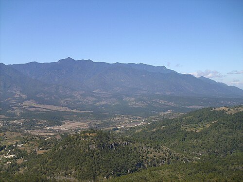
  • Cerro Las Minas

    ETXEVERZ / Public domain

    mountain

    Cerro Las Minas

    mountain in Lempira Department, Honduras

    Opening hours Not checked

    Admission Not checked

    About 12 km from the city centre

    Map

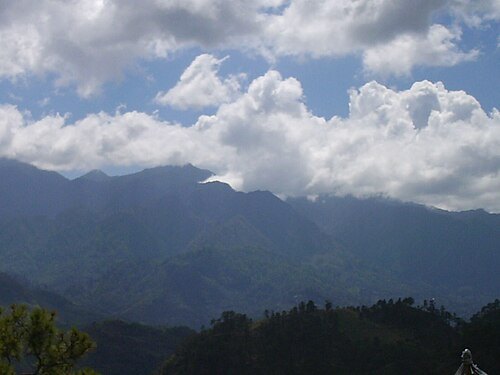
  • Celaque National Park

    ETXEVERZ / Public domain

    national park

    Celaque National Park

    national park in Honduras

    Opening hours Not checked

    Admission Not checked

    About 15 km from the city centre

    Map

  • river

    Higuito River

    river in Honduras

    Opening hours Not checked

    Admission Not checked

    About 16 km from the city centre

    Map

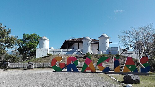
  • San Cristóbal fortress (Honduras)

    Mónica J. Mora / CC BY-SA 4.0

    fortification

    San Cristóbal fortress (Honduras)

    Opening hours Not checked

    Admission Not checked

    Getting there Nearest stop or station Terminal de Buses, about 6 min on foot OpenStreetMap

    Map

  • mountain range

    Cordillera de Puca

    mountains in Honduras

    Opening hours Not checked

    Admission Not checked

    About 16 km from the city centre

    Map

  • mountain

    Cerro Parchapa

    mountain in Honduras

    Opening hours Not checked

    Admission Not checked

    About 20 km from the city centre

    Map

  • mountain

    Pico Puca

    mountain in Honduras

    Opening hours Not checked

    Admission Not checked

    About 18 km from the city centre

    Map

  • river

    Conchaguale

    river in Honduras

    Opening hours Not checked

    Admission Not checked

    About 11 km from the city centre

    Map

  • mountain

    Cerro El Cerraje

    mountain in Honduras

    Opening hours Not checked

    Admission Not checked

    About 14 km from the city centre

    Map

  • mountain

    Tontolilo

    mountain in Honduras

    Opening hours Not checked

    Admission Not checked

    About 19 km from the city centre

    Map

  • mountain

    Cerro Pashapa

    mountain in Honduras

    Opening hours Not checked

    Admission Not checked

    About 17 km from the city centre

    Map

  • mountain

    Cerro Peringual

    mountain in Honduras

    Opening hours Not checked

    Admission Not checked

    About 11 km from the city centre

    Map

  • mountain

    Cerro Quepuquil

    mountain in Honduras

    Opening hours Not checked

    Admission Not checked

    About 13 km from the city centre

    Map

  • mountain

    Cerro Otero

    mountain in Honduras

    Opening hours Not checked

    Admission Not checked

    About 10 km from the city centre

    Map

  • mountain

    Cerro Panalito

    mountain in Honduras

    Opening hours Not checked

    Admission Not checked

    About 18 km from the city centre

    Map

  • mountain

    Cerro Mapitual

    mountain in Honduras

    Opening hours Not checked

    Admission Not checked

    About 9 km from the city centre

    Map

  • mountain

    Cerro Las Pitas

    mountain in Honduras

    Opening hours Not checked

    Admission Not checked

    About 15 km from the city centre

    Map

  • mountain

    Cerro Guatemalia

    mountain in Honduras

    Opening hours Not checked

    Admission Not checked

    About 8 km from the city centre

    Map

  • mountain

    Cerro Jicarillo

    mountain in Honduras

    Opening hours Not checked

    Admission Not checked

    About 15 km from the city centre

    Map

  • mountain

    Cerro Azacualpita

    mountain in Honduras

    Opening hours Not checked

    Admission Not checked

    About 10 km from the city centre

    Map

  • mountain

    Cerro Bilao

    mountain in Honduras

    Opening hours Not checked

    Admission Not checked

    About 19 km from the city centre

    Map

  • mountain

    Cerro Carriyal

    mountain in Honduras

    Opening hours Not checked

    Admission Not checked

    About 11 km from the city centre

    Map

  • mountain ridge

    Cerrito Conejo

    ridge in Honduras

    Opening hours Not checked

    Admission Not checked

    About 19 km from the city centre

    Map

  • mountain

    Cerro Cutijera

    mountain in Honduras

    Opening hours Not checked

    Admission Not checked

    About 19 km from the city centre

    Map

  • river

    Agua Caliente

    river in Lempira Department, Honduras
    Opening hours Not checked

    Admission Not checked

    Map

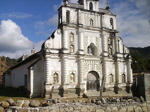
  • Iglesia de San Manuel de Colohete

    ETXEVERZ / CC BY-SA 4.0

    church building

    Iglesia de San Manuel de Colohete

    San Manuel Colohete church in Honduras

    Opening hours Not checked

    Admission Not checked

    About 19 km from the city centre

    Map

  • catholic cathedral

    Cathedral of St. Mark

    Opening hours Not checked

    Admission Not checked

    Getting there Nearest stop or station Terminal de Buses, about 11 min on foot OpenStreetMap

    Map

Places to eat

No eating place in this city lists its cuisine and opening hours yet.

Opening hours and tickets: OpenStreetMap contributors. Each one shows the day a volunteer last wrote it down, so check the official site before you set out.

Nothing picked yet
    Add a place that is not listed here

    One per line. Pasting a list works too.

    Honduras