Ahuachapán: what to see and where to eat

Everything below comes from open data and each row says where it came from. We have not been to any of these places and we do not rank them.

127,301 people live here

Distances are straight-line and the walking time is an estimate, not a route.

Filters

Things to see

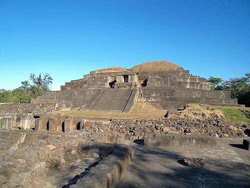
  • Tazumal

    ARamirez69 / CC BY-SA 3.0

    archaeological site

    Tazumal

    archeological site in Chalchuapa, El Salvador

    Opening hours Not checked

    Admission Not checked

    About 20 km from the city centre

    Map

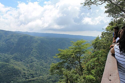
  • El Imposible National Park

    ElmerGuevara / CC BY-SA 3.0

    national park

    El Imposible National Park

    national park in El Salvador

    Opening hours Not checked

    Admission Not checked

    About 15 km from the city centre

    Map

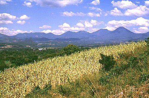
  • Cordillera de Apaneca-Lamatepec

    Lee Siebert, Smithsonian Institution / Public domain

    mountain range

    Cordillera de Apaneca-Lamatepec

    mountain range in western El Salvador

    Opening hours Not checked

    Admission Not checked

    About 14 km from the city centre

    Map

  • stadium

    Estadio Simeón Magaña

    Opening hours Not checked

    Admission Not checked

    Getting there Nearest stop or station Antigua Estación de Ferrocarriles de Ahuachapán, about 3 min on foot OpenStreetMap

    Map

  • river

    Cara Sucia River

    river in El Salvador

    Opening hours Not checked

    Admission Not checked

    About 20 km from the city centre

    Map

  • mountain

    Laguna Verde

    volcano + lake in El Salvador

    Opening hours Not checked

    Admission Not checked

    Map

  • mountain

    Cerro Las Ninfas

    volcano in El Salvador

    Opening hours Not checked

    Admission Not checked

    Map

  • volcano

    Cerro de Apaneca

    volcano in El Salvador

    Opening hours Not checked

    Admission Not checked

    About 10 km from the city centre

    Map

  • mountain

    Cerro de Oro

    Opening hours Not checked

    Admission Not checked

    About 11 km from the city centre

    Map

  • mountain

    Cerro El Cerrito

    mountain in Ahuachapán Department, El Salvador

    Opening hours Not checked

    Admission Not checked

    About 8 km from the city centre

    Map

  • hill

    Loma El Montoso

    Opening hours Not checked

    Admission Not checked

    About 17 km from the city centre

    Map

  • hill

    Lomas Las Ticucas

    Opening hours Not checked

    Admission Not checked

    About 18 km from the city centre

    Map

  • hill

    Cerro Peña Pinta

    Opening hours Not checked

    Admission Not checked

    About 18 km from the city centre

    Map

  • hill

    Lomas de Paja

    Opening hours Not checked

    Admission Not checked

    About 19 km from the city centre

    Map

  • mountain

    Cerro Los Alpes

    Opening hours Not checked

    Admission Not checked

    About 12 km from the city centre

    Map

  • mountain

    Cerro Bonete

    mountain in Ahuachapán Department, El Salvador

    Opening hours Not checked

    Admission Not checked

    About 10 km from the city centre

    Map

  • hill

    Cerro Las Ninfas

    Opening hours Not checked

    Admission Not checked

    Map

  • mountain

    Loma Monte Hermoso

    mountain in Ahuachapán Department, El Salvador

    Opening hours Not checked

    Admission Not checked

    About 11 km from the city centre

    Map

  • mountain

    Cerro El Carrizal

    mountain in Ahuachapán Department, El Salvador

    Opening hours Not checked

    Admission Not checked

    About 13 km from the city centre

    Map

  • mountain

    Cerro El Cucurucho

    mountain in Ahuachapán Department, El Salvador

    Opening hours Not checked

    Admission Not checked

    About 16 km from the city centre

    Map

  • mountain

    Cerro El León

    mountain in Ahuachapán Department, El Salvador

    Opening hours Not checked

    Admission Not checked

    About 13 km from the city centre

    Map

  • mountain

    Cerro El Tambor

    mountain in Ahuachapán Department, El Salvador

    Opening hours Not checked

    Admission Not checked

    About 14 km from the city centre

    Map

  • mountain

    Cerro Mistepe

    mountain in Ahuachapán Department, El Salvador

    Opening hours Not checked

    Admission Not checked

    About 15 km from the city centre

    Map

  • mountain

    Cerro Peña Pinta

    mountain in Ahuachapán Department, El Salvador

    Opening hours Not checked

    Admission Not checked

    About 17 km from the city centre

    Map

  • lagoon

    Laguna del Llano

    Opening hours Not checked

    Admission Not checked

    Map

  • river

    Quebrada El Chagüite

    river in Ahuachapán Department, El Salvador

    Opening hours Not checked

    Admission Not checked

    About 16 km from the city centre

    Map

  • river

    Quebrada El Jutal

    river in Ahuachapán Department, El Salvador - Geonames ID = 3586344

    Opening hours Not checked

    Admission Not checked

    About 19 km from the city centre

    Map

  • river

    Quebrada El Jutal

    river in Ahuachapán Department, El Salvador - Geonames ID = 3810577

    Opening hours Not checked

    Admission Not checked

    About 10 km from the city centre

    Map

  • river

    Quebrada El Tambor

    river in Ahuachapán Department, El Salvador

    Opening hours Not checked

    Admission Not checked

    About 17 km from the city centre

    Map

  • river

    Quebrada La Angostura

    river in Ahuachapán Department, El Salvador

    Opening hours Not checked

    Admission Not checked

    About 20 km from the city centre

    Map

  • river

    Quebrada La Joya

    river in Ahuachapán Department, El Salvador

    Opening hours Not checked

    Admission Not checked

    About 11 km from the city centre

    Map

  • river

    Quebrada Las Lajas

    river in Ahuachapán Department, El Salvador - Geonames ID = 3810597

    Opening hours Not checked

    Admission Not checked

    Map

  • river

    Quebrada Los Muertos

    river in Ahuachapán Department, El Salvador

    Opening hours Not checked

    Admission Not checked

    Map

  • river

    Río Agua Caliente

    river in Ahuachapán Department, El Salvador - Geonames ID = 3765214

    Opening hours Not checked

    Admission Not checked

    About 18 km from the city centre

    Map

  • river

    Río Agua Fría

    river in Ahuachapán Department, El Salvador - Geonames ID = 3810380

    Opening hours Not checked

    Admission Not checked

    About 17 km from the city centre

    Map

  • river

    Río Agua Fría

    river in Ahuachapán Department, El Salvador

    Opening hours Not checked

    Admission Not checked

    About 19 km from the city centre

    Map

  • river

    Río Agua Shuca

    river in Ahuachapán Department, El Salvador

    Opening hours Not checked

    Admission Not checked

    Map

  • river

    Río Amolunca

    river in Ahuachapán Department, El Salvador

    Opening hours Not checked

    Admission Not checked

    About 9 km from the city centre

    Map

  • river

    Río Bebedero

    river in Sonsonate Department, El Salvador

    Opening hours Not checked

    Admission Not checked

    About 17 km from the city centre

    Map

  • river

    Río Ceniza

    river in Sonsonate Department, El Salvador - Geonames ID = 3587121

    Opening hours Not checked

    Admission Not checked

    About 20 km from the city centre

    Map

  • river

    Río Chagalapa

    river in Ahuachapán Department, El Salvador

    Opening hours Not checked

    Admission Not checked

    About 17 km from the city centre

    Map

  • river

    Río Chalguaza

    river in Ahuachapán Department, El Salvador

    Opening hours Not checked

    Admission Not checked

    About 18 km from the city centre

    Map

  • river

    Río Chilapa

    river in Ahuachapán Department, El Salvador

    Opening hours Not checked

    Admission Not checked

    About 10 km from the city centre

    Map

  • river

    Río de Ashuquema

    river in Ahuachapán Department, El Salvador

    Opening hours Not checked

    Admission Not checked

    About 11 km from the city centre

    Map

  • river

    Río de Chacala

    river in Ahuachapán Department, El Salvador

    Opening hours Not checked

    Admission Not checked

    About 15 km from the city centre

    Map

  • river

    Río de Chipilapa

    river in Ahuachapán Department, El Salvador

    Opening hours Not checked

    Admission Not checked

    Map

  • river

    Río de Las Ollas

    river in Ahuachapán Department, El Salvador

    Opening hours Not checked

    Admission Not checked

    About 11 km from the city centre

    Map

  • river

    Río de Tacuba

    river in Ahuachapán Department, El Salvador

    Opening hours Not checked

    Admission Not checked

    About 9 km from the city centre

    Map

  • river

    Río El Imposible

    river in Ahuachapán Department, El Salvador

    Opening hours Not checked

    Admission Not checked

    About 18 km from the city centre

    Map

  • river

    Río El Limo

    river in Ahuachapán Department, El Salvador

    Opening hours Not checked

    Admission Not checked

    Map

  • river

    Río El Molino

    river in Ahuachapán Department, El Salvador

    Opening hours Not checked

    Admission Not checked

    About 11 km from the city centre

    Map

  • river

    Río El Quequeisque

    river in Ahuachapán Department, El Salvador

    Opening hours Not checked

    Admission Not checked

    About 18 km from the city centre

    Map

  • river

    Río El Sunza

    river in Ahuachapán Department, El Salvador - Geonames ID = 3810406

    Opening hours Not checked

    Admission Not checked

    About 15 km from the city centre

    Map

  • river

    Río Grande

    river in Sonsonate Department, El Salvador

    Opening hours Not checked

    Admission Not checked

    About 17 km from the city centre

    Map

  • river

    Río Ishcanelo

    river in Ahuachapán Department, El Salvador

    Opening hours Not checked

    Admission Not checked

    About 11 km from the city centre

    Map

  • river

    Río Los Apantes

    river in Ahuachapán Department, El Salvador

    Opening hours Not checked

    Admission Not checked

    About 14 km from the city centre

    Map

  • river

    Río Maishtapula

    river in Ahuachapán Department, El Salvador

    Opening hours Not checked

    Admission Not checked

    About 19 km from the city centre

    Map

  • river

    Río Negro

    river in Ahuachapán Department, El Salvador

    Opening hours Not checked

    Admission Not checked

    About 15 km from the city centre

    Map

  • river

    Río Nejapa

    river in Ahuachapán Department, El Salvador

    Opening hours Not checked

    Admission Not checked

    About 10 km from the city centre

    Map

Places to eat

  • restaurant

    Restaurante Los Tarros

    Food: regional, traditional

    Mo-Su 09:00-21:00

    Ahuachapan

    Map

Opening hours and tickets: OpenStreetMap contributors. Each one shows the day a volunteer last wrote it down, so check the official site before you set out.

Nothing picked yet
    Add a place that is not listed here

    One per line. Pasting a list works too.

    El Salvador